...

19 views

Geography of Sri Lanka 🇱🇰
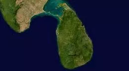
Sri Lanka is an island surround by the Indian Ocean. Sri Lanka is a pearl shaped island in South Asia. Sri Lanka include in natural resources. They are coastel line, rivers, forests, mountains, etc.
Sri Lanka's climate can be described as tropical. They are many verieties of climate in Sri Lanka. The average temperature range betwen 16°C to 32°C. January is the coolest mouth and April is the hotest mouth in Sri Lanka. Everyone can feel every climate changers per day. So,that's why so many tourist come to visit Sri Lanka.
Sri Lanka gets rainfalls all over the year. The main rainfall patterns are; Monsoon wind, Convectional rain, Cyclones. There are two kinds of monsoonal rain. They are Southernwest monsoonal rain and Northeast monsoonal rain. Southernwest monsoonal rain falls in South West side and Western slopes of the central highlands from May to September. Northeast monsoonal rain falls in Northeast side and Eastern slopes of central highlands from December to February. Convectional rains falls March to April and October to November. Cyclones are active on all over the year.
Sri Lanka's Ecological zones are depend on rainwater. The highlands and Southwestern part of Sri Lanka,known as the "wet zone". Wet Zone's annual average rainfall is 2500mm. Southeast, East and Northern part of Sri Lanka ,known as the "dry zone". It's annual average rainfal is 2500mm to 1200mm. Hambanthota district and Manner district known as "subtropical zone". It's annual average rainfall is 600mm to 1200mm.
In 65,610km2 there are so many geographical things include. From the South Asian countries Sri Lanka is second only to the Indian geographical varieties. The natural geography shows Sri Lanka is a self sufficient country to the world.
I'm proud to be a Sri Lankan. 🇱🇰
By,Damehood...